HAKALAU OUR HOME
  • Home
    • Upcoming Events
    • About hakalauhome
    • Contact Us!
  • Yesterday
    • Timeline
    • Camps
    • People >
      • The Ross Families of Hakalau
      • Satoru Kurisu
      • Toraichi Morikawa
      • Waichi Ouye
      • Aigoro Uyeno
    • Schools >
      • Hakalau School
      • John M. Ross School
      • Hakalau Japanese Language School
    • Churches & Cemeteries >
      • Churches >
        • Hakalau Jodo Mission
        • Honohina Hongwanji
      • Cemeteries >
        • Honohina Cemetery
    • The Voice of Hakalau
    • Sugar Production >
      • Hakalau Mill & Other Buildings
      • Wailea Milling Company
    • Transportation >
      • Ships
      • 19th Century Hamakua Roads
      • Bridges >
        • Highway Bridges, 1950-1953
      • The Railroad
  • Today
    • Hakalau Farmers Market
    • Hakalau Jodo Mission Today >
      • Community Commitments >
        • Obon Festival
        • Memorial Day
        • Newsletters
        • PRESENTATIONS
    • Honohina Hongwanji Today
    • Wailea/Hakalau Kumiai
    • Hakalau Reunions
    • Wailea Village Historic Preservation Community >
      • Cemetery Stewardship
      • Reviving Hakalau School
      • Senior Luncheons
  • Then and Now
    • Up and Down Camps and Mill
    • Hakalau School Then and Now
  • Tomorrow
    • Arsenic Remediation
    • Cliff Failures
    • Hāmākua CDP & the CDP Action Committee

Cliff Failures

Picture
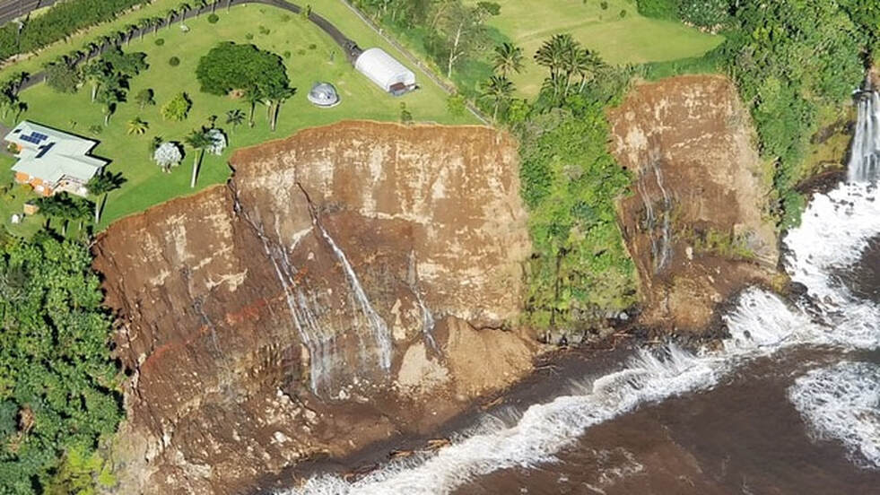
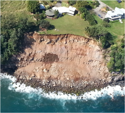
Photo of Umauma property provided courtesy of a private photographer on September 2, 2018 after the torrential rainfall from Hurricane Lane.
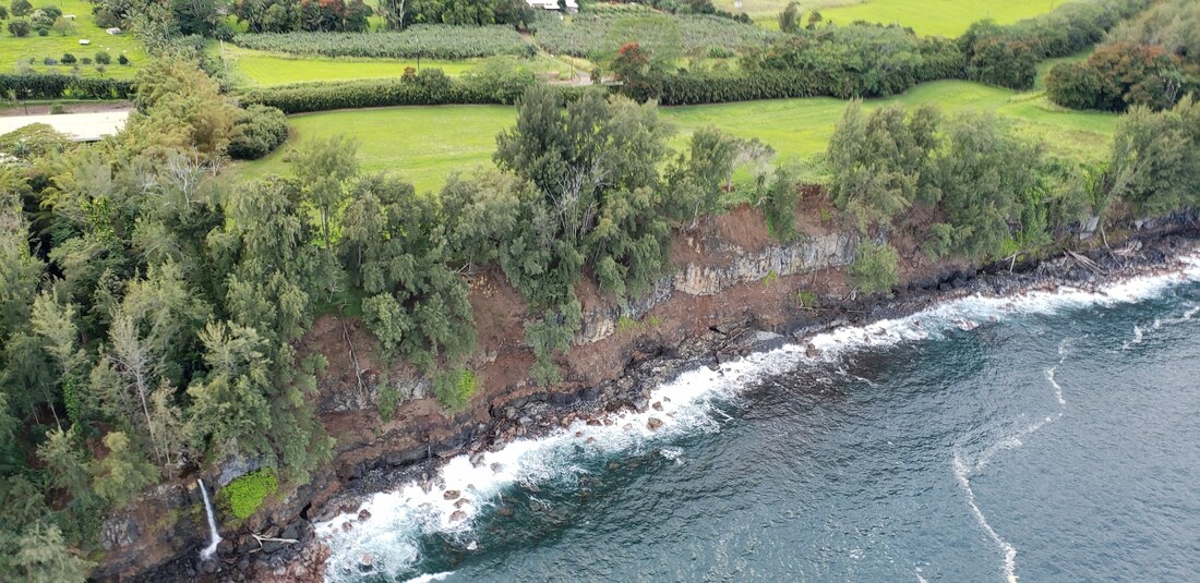
Cliffs along the Hāmākua Coast are subject to failure.

Cliffs along the Hāmākua Coast are subject to failure and erosion hazards from undercutting of the cliffs by waves, and slumping from absorption and release of groundwater. Heavy rains increase the likelihood of cliff failure.The fragile cliffs pose a major challenge for development. Episodic failure can remove 30-100 feet in one event. These types of episodic failures are not only hard to predict, they are impossible to mitigate. Once a failure occurs there is very little a homeowner can do to regain that land.

Cliff retreat is a natural process for any unstabilized steep slope, whether there is development or not. The failure relates to the substrate composition, ocean energy, groundwater flux, meteoric water inputs, and the geophysical aspects of the underlying rock. The Hāmākua cliffs are unstable primarily because they consist of moist soil and clay. The coast is punctuated by surface streams and groundwater "spigots" cascading onto the narrow boulder beach, such as those shown in the pictures below:
Picture
January 2015 Photo by private photographer.
Picture
Note the gushing water coming out of the sides of the cliff, like a large pipe. Photo taken by a private pilot-photographer on September 2, 2018.
Development activities can increase the likelihood of cliff failure. Geologist John P. Lockwood, Ph.D. describes the impact of building ("mechanical disturbance", "load pressure") on Hāmākua's coastal areas in a report dealing with the arsenic contamination on Hakalau Point, dated March 18, 2014:
The entire Hāmākua coastal area, from north of the Wailuku River to Honokaa, is characterized by a mantling of deeply weathered volcanic ash deposits, known varously as the "Pahala" or "Homelani" Ash, which in turn overlie deeply weathered lava flows from Mauna Kea volcano (Buchanan-Banks, 1983; Wentworth, 1938) ... Wherever mechanically disturbed, however, these ash deposits become structurally unstable (Wieczorek and others, 1982), and are subject to "thixotropic" behavior (ability to convert from stable solids to viscous, mobile fluids when under load pressure or on steepened slopes). 
In 2006, the University of Hawai`i Sea Grant College Program published a guide, "Natural Hazard Considerations for Purchasing Coastal Properties in Hawai`i". While most of the guide is geared towards properties on the beach with concerns about sand erosion, there were two common signs of an erosion or coastal hazard problem that apply to cliffside properties. Potential buyers of Hāmākua Cliff properties might want to look out for:
  • Eroding bluffs or scarps often show vegetation roots or recent debris at the base of a cliff. Moisture seeping out of a clay or dirt bank is also a sign of erosion potential. Notches or indentations at the base of a cliff, living or dead trees on the open beach can indicate undercutting by waves.
Picture
  • Vertical banks, often at the seaward edge of vegetation, anywhere from one foot to several feet high; or vegetation, rocks or structures that are falling over.
Picture
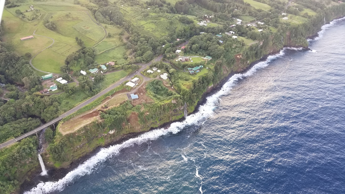
The vertical cliffs of the Hamakau Coast viewed here from about the Mile Marker 19 looking north. Photo courtesy of a private pilot-photographer, taken on October 21, 2018.

Environmental Harm

In addition to the potential harm cliff failures pose humans and property, they also cause long-term harm to the shoreline habitat and nearshore waters:
  • The sediment load in the water kills marine life by suffocation and may contribute agricultural chemicals, harmful to sedentary animals and algae.
  • The slide destroys and permanently alters the habitat. Recruitment of species won’t occur for a very long time, and may never occur again. An example of this is the loss of `opihi (mollusk) and wana (sea urchin) fishing grounds along the coast. 
  • Local divers have noticed a thin veneer of silt in the turf algae covering the boulders characteristic of the Hāmākua nearshore habitat.
  • Any pollutants in the soil, such as the cliff-side arsenic lode at the old sugar plantation sites such as Hakalau Point can be a source of leachate. Sugar plantations were very common along the Hāmākua Coast from Haina town to Hilo town and most these abandoned sugar mill sites were never surveyed for chemical contaminants. (see Sugar Islands: The 165-Year Story of Sugar in Hawaii, pp. 82-83) ​
​Good descriptions of the impact of cliff failures on marine life are included in Dr. Robert Nishimoto's articles in the Hāmākua Times: "Hāmākua Cliff Slides and the Hawksbill Turtle: The Perfect Storm” and "The Lonely Life of the Hāmākua `Opihi".
Picture
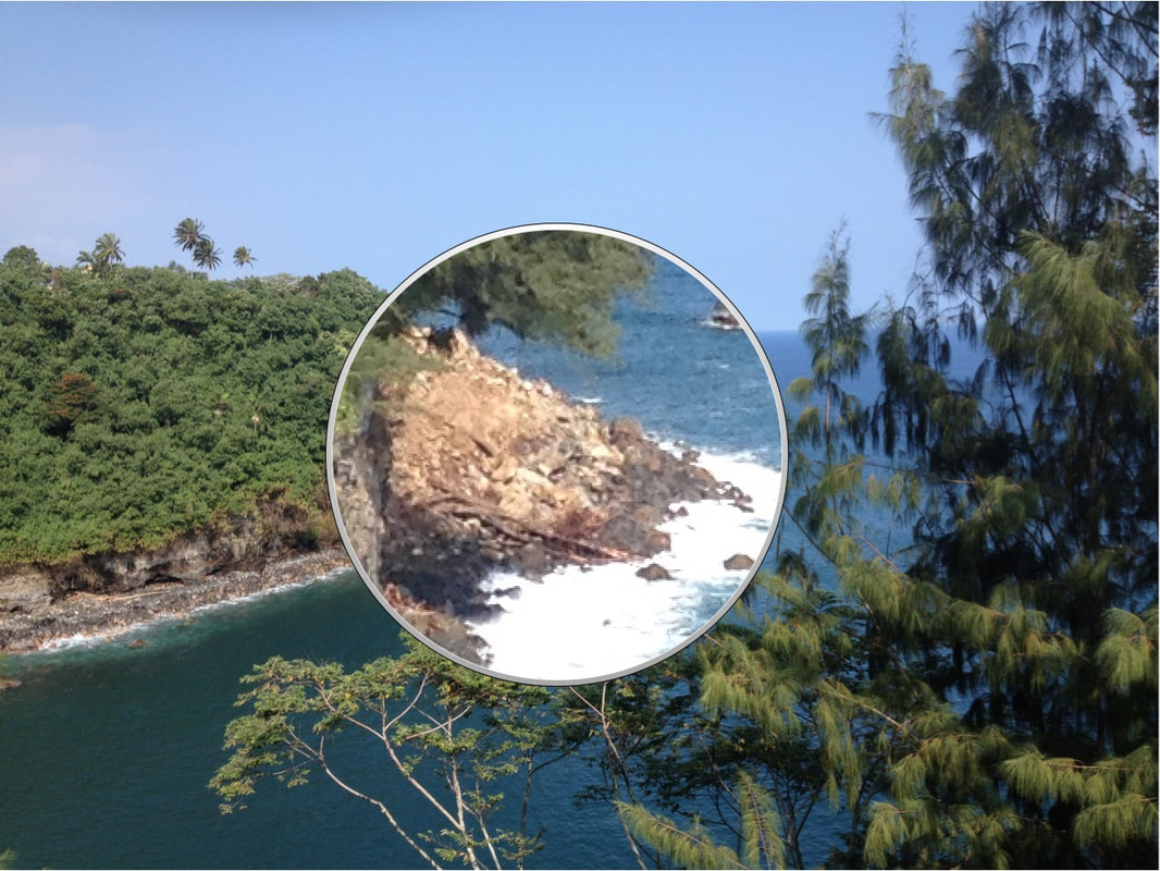
Detail of side view of January 2015 Cliff Failure immediately north of Hakalau Bay at about the 16 mile marker, showing debris including rocks, dirt and trees. As of September 2018, this slide is still causing harm to the environment. Photo courtesy of Cal Motoda. Photo courtesy of Calvin Motoda, 1/12/2015.
Picture
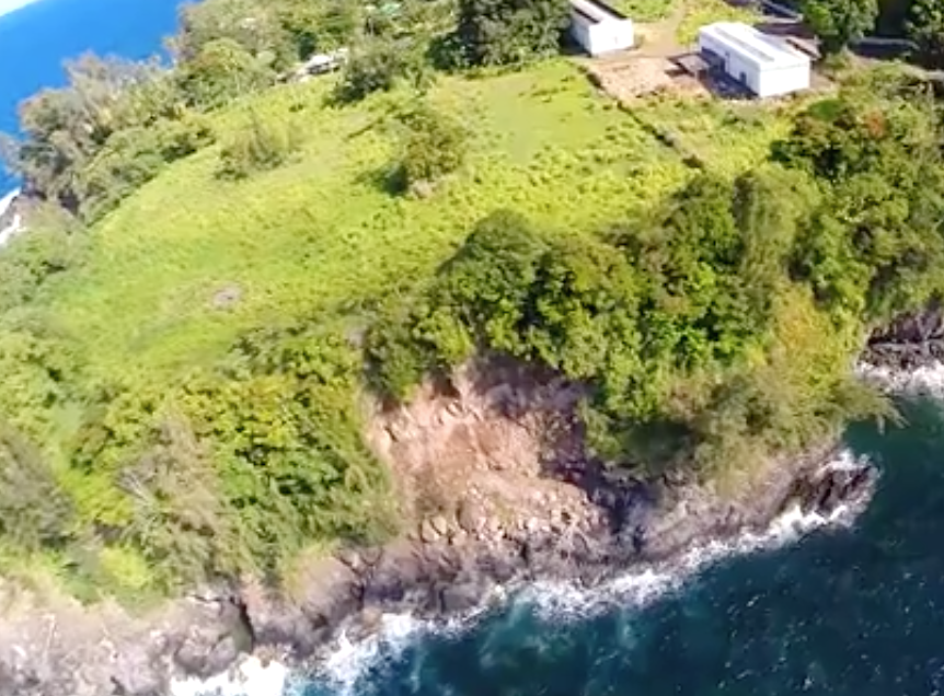
July 2014 view of Hakalau Point showing cliff failure in area of high arsenic concentration. Accessed via vimeo.com/100024063

New Shoreline and Building Setbacks are Needed Now

The Hāmākua​ Community Development Plan includes Policy 18 acknowledging the cliff failure dangers associated with cliffside development issue and recommends:
Amend and/ or create County Codes and Planning Department Rules to develop shoreline and building setbacks to address environmental, health, and safety priorities.
Full Text of Policy 18
Photos taken by a private pilot-photographer on January 24, 2020, after the record-breaking rainfall
during the weekend of January 11-12, 2020. The properties shown are in Umauma and Ninole.

Research progresses towards evidence-based set-backs 

A research team comprising staff from the Pacific Islands Climate Adaptation Science Center (PI-CASC), the University of Hawai’i and the County of Hawai’i Planning Department recently set out to quantify historic and contemporary rates of change along different types of shorelines on Hawai’i Island, using those data to model observed changes into the future through sea level rise impacts.

PI-CASC is a partnership between the U.S. Geological Survey and a three-member university consortium: the University of Hawai’i at Manoa (the consortium lead), the University of Guam, and UH Hilo. PI-CASC develops research products (information, tools, and techniques) that strengthen the capacities of natural and cultural resource managers across the Pacific to anticipate and adapt to climate change impacts.

On Hawai’i Island, a “setback policy” requires developers to place buildings at least 40 feet from the established shoreline across the entire island. This largely arbitrary line did not account for different uses of the land, nor the constantly shifting environments distinct to the island’s different shoreline types. Ultimately, it left some communities exposed to coastal hazards.
​
The research team combined existing datasets (historic aerial photos) with new data (drone imagery, topographic surveys, etc.) to quantify past and present rates of coastal change. These data were then merged with sea level rise projections and other geospatial data to estimate future impacts along the coastline using a GIS platform.
USGS Video
Read the Case Study
​Much work remains to develop objective guidelines for determining and defining the " top of cliff", and to establish revised building setbacks which include a lateral safety buffer distance equal to the anticipated 100 years of erosion based on a coastal erosion study.  Currently, there is a grant application into FEMA, and agreement with the state Coastal Zone Management program to “do the site work to be able to establish research-based shoreline setback.”

Cliff Failures within the Hakalau Kuleana

The Hakalau Kuleana, the focus of this website, includes the area of the former Hakalau Plantation, from the Kolekole River in Wailea to  the Poupou Stream in Ninole. Using Highway 19 as a measure, the Hakalau Kuleana extends from Mile Marker 14 to Mile Marker 20. In the pictures below, Hakalau Kuleana cliff failures are both common and dramatic. ​
The view from the air:
Photos by a private pilot-photographer taken January 24, 2020 after heavy rains. Note the sediment in the water.
A private pilot-photographer took the pictures below on February 25 and March 29, 2019 (from 2,500 feet).
The view from the ocean:

Photographs taken at sea level looking back at the cliffs were provided by retired marine biologist Robert Nishimoto, PhD. in March 2018. They  provide another perspective of the extensive cliff erosion and cliff failures from Kolekole to Ninole.
For the Hakalau Kuleana, our responsibility is to care for the land, the people, and the culture. We are guided by cultural values of YESTERDAY: Engage in collective effort. Look out for each other. Honor hard work. Show respect for those who came before us. Aloha and Mālama `Aina. In 2021, Akiko Masuda added two more values to the list: Consistently show up. Whatever has to be done, jump in and do it!